Out of Eden Walk
The Out of Eden Walk is a 24,000-mile journalistic endeavor to create a global record of human life at the start of a new millennium as told by villagers, nomads, traders, farmers, soldiers, and artists who rarely make the news. Sponsored and hosted by National Geographic Society, the project is led by Pulitzer Prize winning writer Paul Salopek who is walking the path of human migration across the globe, and recording what he encounters in the form of writing, photographs, video, and audio.
Investigator: Paul Salopek
Project staff Jeff Blossom
Grant Funding: Funded by the National Geographic Society
As a partner in this project the CGA’s role includes mapping Paul’s walking route from his GPS data and publishing it on the Completed Route Map, custom thematic map creation, essay writing and cartographic education by the CGA's Jeff Blossom. Toward the project's educational focus, Jeff has provided hands on cartographic education centered around the Walk. Watch the 2020 video Mapping The Human Journey for more on this effort. Jeff has taught mapping to the following K-12 classrooms:
2025: 65 students from pre-K to 8th grade at Touchstone Community School, Grafton, MA. 55 4th Graders at Merriam Elementary School in Acton, MA.
2024: 70 kindergartners in person, at Stratton Elementary School in Arlington, MA.
2023: 1 4th grader and 1 6th grader in person, for 2 sessions. Homeschooled from Eastham, MA, in July. | 60 4th Graders in 3 in person sessions. Merriam Elementary School in Acton, MA. View a link to the presentation from this session.
2022: 68 4th Graders in 3 in person sessions. Merriam Elementary School in Acton, MA.
2021: 142 6th Graders in 4 virtual sessions. Concord Middle School, Concord, MA. | 54 4th graders from Merriam Elementary School in Acton, MA in one virtual session.
2020: 96 6th Graders at Concord Middle School, Concord, MA.
2019: 115 6th Graders at Concord Middle School, Concord, MA | 105 High school seniors, New York City Labs School | 70 6th Graders, Meriam Elementary School, Acton, MA | 80 7th Graders, Robert Adams Middle School, Holliston, MA.
2018: 122 High school seniors, New York City Labs School | 90 High school freshman, Lewiston High School, Lewistin, Maine | 75 7th Graders and 90 6th Graders, Robert Adams Middle School, Holliston, MA | 180 3rd, 4th, and 5th grade students at the Dhirubhai Ambani International School, Mumbai, India | 60 9th grade students at the Sri Sri Academy in Kolkata, India. Read more on the project activities in India.
2017: 115 High school seniors, New York City Labs School | 70 6th Graders, Meriam Elementary School, Acton, MA | 80 6th Graders, Robert Adams Middle School, Holliston, MA. View the My Personal Geography mapping exercise given at this session.
2016: 22 High school students, Baltimore, MD | 125 High school seniors, New York City Labs School | 82 7th Graders, Lincoln Middle School, Portland, Maine | 94 6th Graders, Meriam Elementary School, Acton, MA | 80 6th Graders, Robert Adams Middle School, Holliston, MA.
Maps made or contributed toward by Jeff Blossom and other CGA members are listed below by the most recent.
Updated Police Stops Map (2026) - Read Paul's dispatch and view the interactive map.
Essay: (2025) Measuring the Out of Eden Walk’s Milestones and Calculating Distances Between Them
3D Animation (2024) - Paul's GPS data from 2013 - 2023 animated on a 3D globe by Eamon Breen, Jacqui Schlesinger, Navya Tripathi, and Jeff Blossom. Turn on your sound and maximize the video on your screen for the best viewing experience.
Walking the Alleyways of Beijing (2024) View the story map.
GPS data (2024) The files linked to below are for any cartographer to use, but need to be opened in geospatial software, such as Google Earth, QGIS, or ArcGIS:
The updated route data in line format in full detail as of January, 2026 to Gustavus, Alaska in shapefile format.
The updated route in line format simplified to approximately 500 meter segments (will be easier to work with for smaller geographic scales): Kml format | JSON format | Shapefile format
The enriched GPS data that includes latitude, longitude, time, elevation, slope, population density, land cover, and nearest village for all GPS points recorded by Paul is published on the Harvard Dataverse at this link.
Poster presentation (2023) - Eamon Breen presented "Advancements in 3D Cartography and Visualization: Mapping Human Migration" at the annual American Association of Geographers conference in Denver, CO. View the poster.
Out of Eden Walk Presentation (2022) - Daniel Weinstein's presentation at the University of California GIS Week, primarily discussing his work enhancing the walk's GPS data with population density, land cover, elevation, and slope. The presentation can be viewed at this video link, from minute 0:44 - 19:45.
Digital Donor Map (2017 - 2022) Part of the Out of Eden Walk is funded by individual donors. People contributing over $25 become "mile sponsors", and get their name associated with a mile on the Digital Donor Map.
Echos of the Invisible (2021) This film by cinematographer Steve Elkins features The Greatest Walk map, and includes an extensive interview with Paul Salopek and additional footage of Paul on The Walk.
Walking Yangon (2021) - An article and story map by Jeff Blossom features a 10-mile hike through Myanmar’s biggest city that reveals a coup’s toll on a once lively metropolis. Additionally, Abigail Sutcliffe replicated this story map using the new ArcGIS Story Map builder, see Abi's work at this link.
The Kinks Map (2021) - A story map depicting unexpected twists on the Out of Eden Walk.
24,000 Miles: From Harvard to Eden (2021) - An article in the Harvard Crimson's publication Fifteen Minutes on Harvard's involvement with the Out of Eden Walk.
A Human Approach to Human Migration (2020) - Cartographic renderings and ruminations on human migrations by Samantha Carr, with an introduction on the OOEW site by Jeff Blossom.
Police Stops (2019) - An article and web map about mapping police stops on a global walk.
Walking Kolkata (2018) - A story map and article about daily life—and death—in India’s "city of joy."
An Atlas of Thinking: Mapping by Middle School Students (2018) - An essay and photos from teaching mapping to middle school students.
Mapping 10 Million Footsteps (2016) - An article and various maps showcasing some of these footsteps.
Walking Baku (2015) - An interactive map with photos and narration about a walk through Baku, Azerbaijan.
Walking Tbilisi (2015) - An interactive map with photos and narration about a walk through Tbilisi, Georgia.
The Tblisi Summit (2015) - An article with maps about The Out of Eden Walk's staff meeting in Tbilisi, Georgia, and a story map A Trip to Tbilisi.
Compass Bearings (2014) - "Neighborhood meanders" - An essay on mapping GPS data.
Turbulent Origins (2014): An video (3 mins.) detailing the history human conflict in The Levant.
Compass Bearings: Mapping Ancient Seabeds (2014): An essay with maps.
Walking Jerusalem (2014) - An interactive map with photos and narration about a walk through Jerusalem.
Compass Bearings: Mapping Year One of the Out of Eden Walk (2014): An essay with maps.
Segmet Metrics (2013): Splitting the walk into two segments for comparision. An essay and map.
Walking Jeddah (2013): An interactive map with photos and narration about a walk through Jeddah, Saudi Arabia.
Pilgramage Routes (2013): Home to Islam’s two holiest cities — Mecca and Medina — the Hejaz has long been a fabled destination for travelers. Trace the ancient routes of pilgrimage, trade, and war through this interactive map.
Afar Terrain (2013): A shaded relief map of Paul's route through this region.
The Greatest Walk (2013). Depicts exposed sea beds at the human migration started, and the rough path humans blazed.

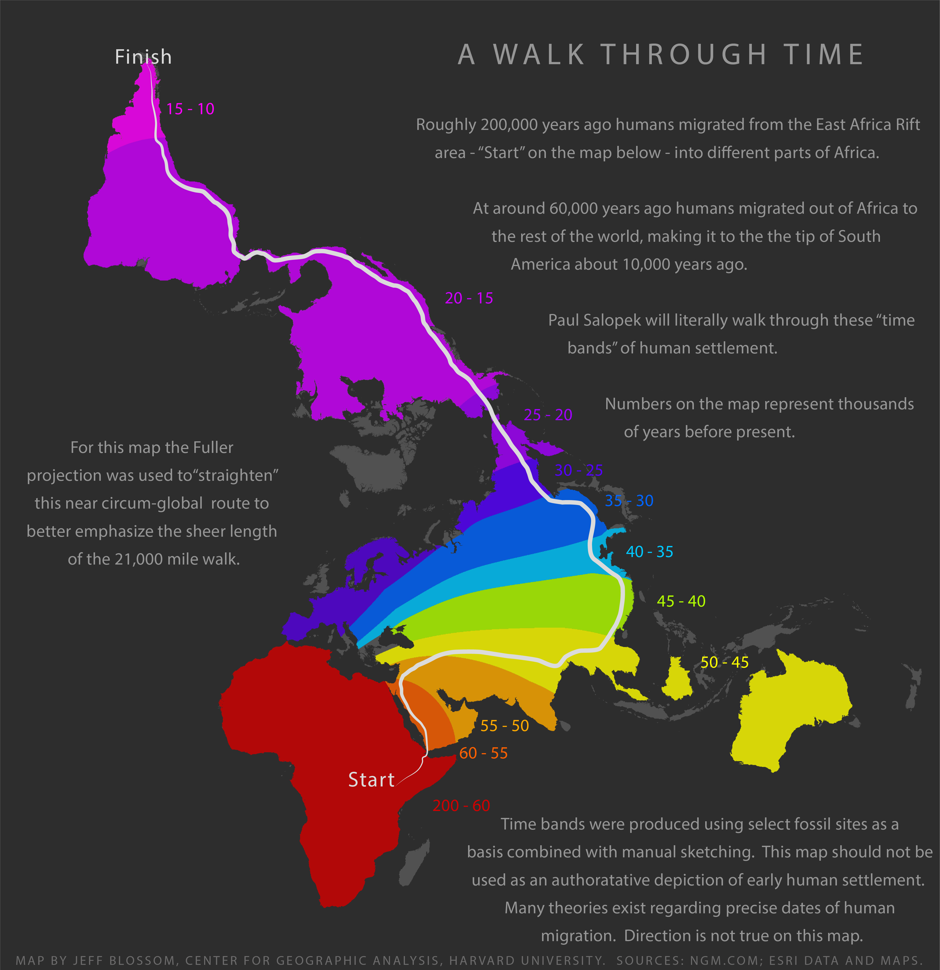
A Walk through Time (2013): Map visualizing the estimated timeline of early human migration. The first map made for the Out of Eden Walk project.